Ice Age Floods: “The Great Missoula Floods”
by Randall W. Carlson [ read on Cosmographic Research page ]
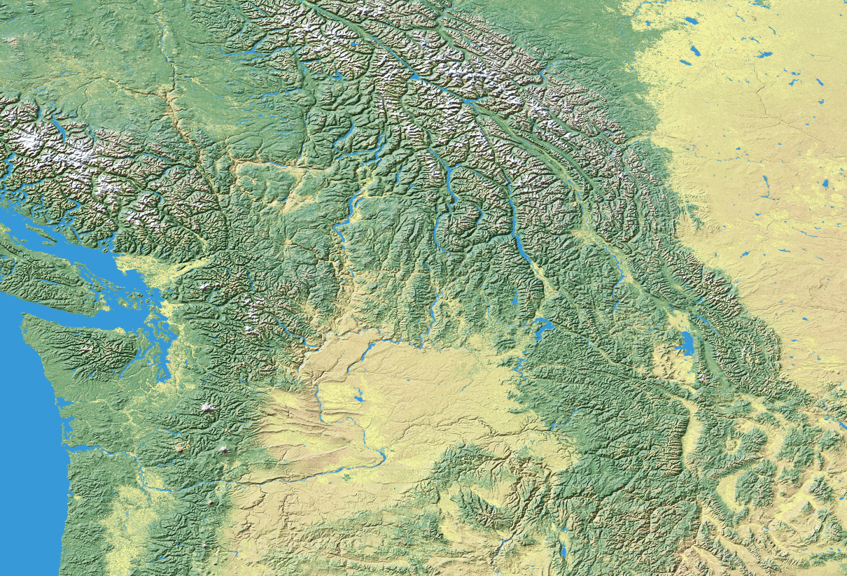
The generally accepted theory as to the cause of the Missoula Flood, or floods, is that a dam of glacial ice, moving out of Canada, filled the mouth of the Clark Fork River just east of its present day confluence with Lake Pend Oreille, near the Idaho-Montana state line. This glacial dam blocked the westward flow of the Clark Fork River causing it to rise against the dam until it eventually reached a depth of close to 2,100 feet, all the while backing up hundreds of miles into the mountain valleys of western Montana. Eventually the lake held over 500 cubic miles of water. At this point, so the theory goes, the dam gave way, allowing the impounded water to flow out across the Idaho Panhandle, through the valley in which the city of Spokane is now located, then to spill out over the great Columbia Basalt Plateau of eastern Washington, carving a series of branching erosional scars and canyons, flowing south until it reached Wallula Gap, a topographic bottleneck at the southwestern margin of the plateau, from whence it entered the Columbia River Valley to begin the final leg of its journey to the sea. Finally, having traversed the gorge from Wallula Gap, the waters crossed the area where Portland is now located, then flowed north and west into the Pacific Ocean. But so great was the volume of flood water that the valley north of Portland could not convey all of it, causing the excess to back-flood far south into the Willamette Valley of Oregon, forming a temporary ponding of water 400 feet deep.
Above the Wallula Gap bottleneck, in the Pasco Basin, the waters backed up into adjacent river valleys such as the Yakima and Walla Walla forming a temporary lake nearly a thousand feet deep.
While a number of geologists, explorers and researchers played a role in the discovery of the Missoula Flood during the late Nineteenth Century, the two key players during the first half of the Twentieth Century were J Harlen Bretz, a geologist with the University of Chicago and J. T. Pardee with the U.S. Geological Survey. Bretz primarily studied the remarkable erosional and depositional effects over the region of the Columbia Basalt Plateau in eastern Washington in the early 1920’s and proposed catastrophic flooding as the primary cause. To this region he gave the name “Channeled Scabland” after a descriptive colloquialism employed by settlers and farmers for the agriculturally useless land which had been swept clean of topsoil and presented a scarred and scoured appearance to the casual observer. Pardee, on the other hand, studied the evidence for the former existence of a massive body of water, which he assumed to be a lake, in the mountain valleys of western Montana. To this ancient lake he gave the name Glacial Lake Missoula, after the city in Montana that is, at present, located at a place that was at the bottom of one of the primary reservoirs of the lake. At this site the water stood about 1000 feet deep and left visible shorelines along the local mountainsides.
Initially, Bretz’s ideas met with considerable resistance from the geological community, who felt geology had advanced beyond the untenable Diluvialism of earlier generations, which, it was assumed, was based upon scriptural dogmas rather than scientific evidence. The doctrine of Uniformitarianism had only gained ascendancy over rival interpretations a generation earlier and many geologists felt that Bretz was stepping outside the bounds of acceptable convention with his descriptions of colossal catastrophic floods. To these geologists Bretz represented a throwback to a less scientific time. In some ways the uniformity-minded geologists can’t be blamed for their initial objections, because, what Bretz was proposing, was in fact, truly incredible. The Doctrine of Uniformity demanded a reference to modern, observable processes in the interpretation and explanation of past events, after Archibald Geikies’ famous dictum that ‘the present is the key to the past,’ and quite frankly, nothing in modern experience even remotely approached the phenomenal scale of the events Bretz was invoking to explain the origin of the Channeled Scabland.
Throughout the Twenties and Thirties Bretz wrote a series of papers describing his findings and responding to his critics. The controversy that raged provides an exceptionally interesting lesson in the workings of the scientific method, and an example of the tenacity with which entrenched dogmas can prevail over widespread evidence to the contrary. Eventually Bretz was vindicated, and towards the end of his long life he was the recipient of the Penrose Medal, the highest honor bestowed upon a geologist.
Pardee’s work on Lake Missoula was published in two principle papers which bracketed his career like bookends – his first paper on Lake Missoula was his first professional publication, in 1910, and his second paper was his last, published in 1942 at the conclusion of his professional career with the U.S.G.S. In the first paper he documented the horizontal lineation on the mountain slopes in the Missoula, Bitteroot and Flathead valleys, which, he realized were shorelines of an ancient lake and these he assumes to have been formed during Ice Age times by glacial damming somewhere to the west, in the valley of the Clark Fork River. This idea he attributes to geologist T.C. Chamberlin who studied the geology of western Montana in the late 19th Century. In his final paper he cites evidence for what he interprets as evidence for rapid draining of Lake Missoula. This evidence includes giant current ripples in Camas Prairie Basin, extensive scouring throughout the valley of the Clark Fork River and large delta deposits at the mouths of various tributary valleys along the major lake drainage routes.
It is our impression that the theory of a glacially dammed lake, first proposed in the Nineteenth Century by T. C. Chamberlin, has been accepted far too uncritically by Uniformitarian-minded geologists, who assume one can simply extrapolate upwards from the conditions of modern ice- dammed lakes and the outburst floods which are frequently associated with them. We would suggest, however, that an examination of modern glacial lakes and outburst floods indicates the total inadequacy of glacial ice to act as any kind of barrier to the flow of water under pressures exceeding a couple-of-hundred pounds per-square-inch. Pardees’ endorsement of an ice dam formation of Lake Missoula is offered rather tentatively. He states: “Belief that the lake was ice-dammed was suggested by certain of the phenomena of this area, but is based mainly on information derived from the writings of others, from which also the probable location of the dam is determinable.” (Pardee, 1910, The Glacial Lake Missoula, Journal of Geology, vol. 18, no. 4, p. 376) The “writings of others” to which Pardee refers is primarily that of Chamberlin, who only speculated upon the existence of an ice dam but did no investigation of the region of the putative ice dam for actual evidence of such. Upon the strength of this statement, the theory that an ice dam was responsible for the formation of Glacial Lake Missoula ultimately rests, and, hence the corollary that it was the failure of this ice dam and subsequent draining of the impounded lake that created the suite of catastrophic flood features found throughout the region.
The most frequently cited argument by Bretz’s critics was the lack of a source for the prodigious amounts of floodwater, and their rejection of any plausible mechanism capable of provoking the degree of accelerated glacial melting demanded by his theory. Yet, through dogged determination, season after season, Bretz continued to document the field effects that, taken as a whole, could not be explained by any other cause than flooding on a scale totally beyond anything ever imagined by geologists. The ice dam model appeared to provide the means whereby geologists could accept the inevitable implication of Bretz’s massive documentation of catastrophic flooding without betraying the ideal of Uniformitarianism, which had become established as the cornerstone of 20th Century geological thinking.
It should be emphasized that in Bretz’s early work he conjectures that the flooding was caused by accelerated glacial melting, augmented by intensified warm rainfall, possibly associated with a short-lived climatic warming. The field evidence he eventually amassed in support of the reality of catastrophic flooding was incontrovertible, and much of that evidence seemed consistent with his concept of combined melting and rainfall, however, he generally neglected the question of causation― what would provoke melting on the scale adequate to produce the magnitude of the flooding implied by the vast erosional complex of the Channeled Scabland. Critics pointed to the lack of any known agency to produce such melting and concluded, therefore, that there had been no floods of the dimension advocated by Bretz.
However, general acceptance of his vision of a vast mega-flood sweeping over large portions of the Pacific Northwest began after Pardee’s second publication of 1942. This paper, already referred to, was rather circumspectly entitled “Unusual Currents in Glacial Lake Missoula, Montana.” Pardee proposes an extremely rapid draining of Lake Missoula due to failure of the hypothetical ice dam suggested in his 1910 paper. It was clear from Pardee’s studies in the Clark Fork River valley that great currents of water had passed through it flowing westward, towards eastern Washington and the Channeled Scablands. From Pardee’s time to the present, with almost no exception, geologists have subscribed to the belief that this flow of water and the ensuing flood was the result of the failure of an ice dam after it had managed to retain a gigantic glacial lake, which, at the region of the ice dam itself would have been at least 2,000 feet deep.
Ice-dammed lakes do presently exist, and sometimes these lakes do burst through their retaining dam of glacier ice, causing locally catastrophic flooding. Additionally, there is in Iceland a type of glacial outburst flood caused by sub-glacial volcanic melting that can produce a considerable amount of glacial melt-water. This melt-water, under pressure, finds its way to the ice sheet perimeter where it bursts out in the form of a short-lived flash flood called in Icelandic “jökulhlaups.”
The essence of the creed of Uniformitarianism is to explain all past phenomenon in terms of presently observed phenomenon. So, when the theory emerged of an out-bursting ice-dammed lake, albeit larger than any modern example, it provided the rational needed by Uniformitarianism and thereby appeared to obviate the necessity of abandoning the dogma of modern analogy in order to accept the now virtually indisputable evidence for a diluvial cataclysm. In other words— for years geologists had rejected the idea of a massive flood because no modern, observable mechanism was in operation that could produce the required amounts of water called for by Bretz’s theory, and dogmatic Uniformitarianism demanded exactly that to be considered serious geological science. However, with the appearance of the idea of a glacially dammed lake and subsequent draining, which does, in fact, have a modern counterpart, the requirements of Uniformity were met, i.e. ‘the present is the key to the past.” It didn’t seem to matter that modern, self-dumping glacial lakes and their resulting floods are miniscule when compared with their ancient glacial counterpart in the Pacific Northwest. The tacit assumption was made that one could simply extrapolate upwards as necessary to generate a conceptual framework within which to explain events otherwise utterly beyond anything within modern human experience.
It is perhaps understandable why Bretz, after so many years of rejection, would eventually endorse the ice dam model, because, after all, this model of flood generation was responsible for the belated acceptance of his work by the geological community, never mind that in all of his early work his interpretation was one of accelerated glacial melting. We can only assume that Bretz finally conceded that no natural mechanism existed capable of melting the quantities of ice necessary to generate such tremendous water-flows as implied by the vast erosion of the Columbia Basalt Plateau.
It is not our intention in this limited summary to examine the competing theories offered in response to Bretz’s early interpretations. Suffice it to say that they have been discarded as historical relics. We would state, however, that certain of the alternate ideas offered actually had merit, particularly the work of Ira Allison, who rejected the pace of erosion demanded by Bretz, but in fact proposed a mechanism that undoubtedly did play a significant role in the totality of the process – namely “iceberg jamming”. We will address Allison’s work in a more extended treatment of this revisionist interpretation in which we shall see that it does more effectively explain certain evidence, namely rhythmical deposition of sediment layers, than do the alternatives.
For our purposes here, let it be explained that during the two decades subsequent to Pardee’s work of the early 1940’s on Glacial Lake Missoula and its draining, the idea of a catastrophic flood gained general acceptance by the geological community. The evolution of Bretz’s thinking during this time, and undoubtedly resulting from additional workers contributing ideas, led him to conclude that rather than a single, extremely large flood, there had actually been a number of catastrophic floods operating over a longer time span. Eventually, he concluded, there may have been as many as seven floods. This, of course, required the formation of multiple Lake Missoula’s and therefore of multiple ice dams, unless it could be shown that there were other potential sources of water. Later geologists, on a number of occasions tentatively offered certain suggestions as to causes and sources, but nothing substantial enough to replace the theory of an out-bursting, glacially dammed lake as the sole, or at least the primary cause of the flooding.
It should be emphasized that the evolution to multiple floods began with the abandonment of the idea of accelerated glacial melting and acceptance of the ice dam model. In fact, the ice dam model demanded the endorsement of multiple floods in order to explain the totality of flood-produced features in all their complexity. In fact, as studies evolved into the 1980’s and 90’s it became necessary to invoke as many 80 floods in an effort to account for the shear diversity and widespread distribution of the erosional and depositional phenomena attributed to gigantic water-flows.
With the departure of J Harlen Bretz, who co-authored his last paper on the subject in 1969, a new era of research was embarked upon by a new generation of geologists in the 1970’s. The most important work of this period was probably that of Victor Baker, then with the University of Texas, who analyzed the flood processes in terms of quantitative hydrology, and actually concluded that Bretz’s and Pardee’s estimates as to peak flood volume were too low. He focused primarily on the flood reach in the Spokane Valley, just below the assumed point of flood release in the region of Lake Pend Oreille. His startling conclusion was that through this reach of the flood, peak discharge was some 752,000,000 million cubic feet per second, perhaps even greater. This is a phenomenal water flow. It has been stated that it is some ten times greater than the total combined flow of all rivers on Earth. However, an unresolved discrepancy emerged with the new calculations. Pardee’s 1944 estimate as to the peak flow passing through the Clark Fork Valley, the presumed outflow of the lake subsequent to ice dam breach, was in the order of 390,000,000 cfs. Baker’s estimate indicated a peak flow almost double that calculated by Pardee. To the very limited extent that this discrepancy has been addressed in the literature, it was merely to say that Baker’s more sophisticated formula yielded or more accurate estimate as to actual peak discharge.
By relying on the mechanism of a glacially dammed lake the larger significance of the Missoula Flood has been obscured. This orthodox model confines the phenomenon of the flood to within the limits of the lower Columbia River watershed. While the flood would admittedly have been a catastrophic event for anyone in its vicinity, certainly anyone in the path of the floodwaters, it would not
necessarily be of any consequence to someone living elsewhere on the continent, much less somewhere else on Earth. But we believe that the evidence now in hand indicates that the Missoula Flood was the regional manifestation of a much larger event. The extreme meltwater flooding was not confined to the Channeled Scabland or to the Columbia Gorge, but was present in all areas of the continent with watersheds heading on or near the ice sheet. In addition, severe flooding effects are also present in most of the watersheds of North America that were not adjacent to the ice sheets. What makes the Missoula Flooding so spectacular are the steep gradients over which the waters traveled on their way to the sea as compared with other meltwater routes discharging from other areas of the ice sheet margin. In the next part of this exposition we will examine the evidence for trans-continental flooding…
